|


?
?
|
Batavia
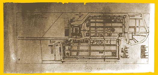
Map of Batavia; 18th century; Batavia
Material: linen paper
Size: l. 48 cm; w. 18 cm
Museum Ref: 15
This map displays Batavia, centre of the city in 1731. The map made by the VOC, depicts situation in Batavia, with main street, rivers/canals, important buildings and so forth. The centre of the city was divided into Westzijde v/d Stad (Western City) and Oostzijde v/d Stad (Eastern City), separated by a canal.
An embankment, or city wall, was built encircling the city border, with three main entrances, namely Poort Utrecht (Main Entrance in the West), Poort Rotterdam (Main Entrance in the east) and Diest Poort (Main Entrance in the South). In the eastern part of the city is palace citadel on the seashore (De Kaastel). On the southern part, outside the city wall, was a satellite town (Voor stad), located in the meeting of current of the Krukut and Cuiliwung river.
Important buildings include:
1. Eastern city, city hall, a warehouses, a church and a hospital
2. Western city, port, a hospital, an orphanage building, a prison, a Portuguese church, market and a drug store.
|


