|
 Kalimantan Kalimantan
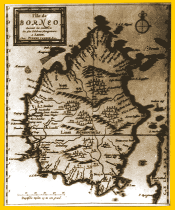
Map of Kalimantan; 17th century; Leiden
Material: paper
Size: l. 18.5cm; w. 15.5 cm
Museum ref: 06
This old colour map of Kalimantan was made by Pierre Vander AA in the 17th century. The form of the island was imperfect, with equator cutting the middle part of the island. The map displays big rivers including Lauwe Flu (Kapuas) and Barito. Several small rivers are also visible. The map also shows several important towns and kingdoms like Banjarmasin (Banjarmasin), Succadana (Sukadana) and Sambas. In the middle part of the map is a mountainous area covered with thick forest. An Indonesia-Hindu kingdom was centralized in Nagara Dipa in South Kalimantan. Daha and Kahuripan were located at the upper course of Nagara river in Amuntai area. The kingdom had established a relationship with the Majapahit Kingdom during the reign of Suryanata, following his marriage with princess Jungjung Buih.
By the end of the 16th century, the Banjar Kingdom became a strong kingdom with Sukadana, Kota Waringin and Lawe under its influence. Banjar has been long recognized by the Dutch since 1596 and Portuguese since the 16th century through trade links. They purchased camphor, diamond and bezoar stones. Banjarmasin was used by the Dutch as an area to store pepper they collected from local areas throughout Kalimantan.
|


